Birla Punya Direction
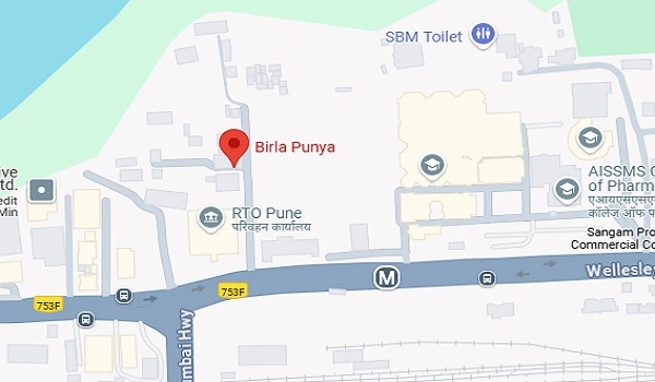
Birla Punya Direction shows the location of the project from other parts of the city. The project is located on Wellesley Rd, near AISSMS College, Sangamvadi, Pune, Maharashtra 411001. This area is easy to find and has many important places around.

Here is the Birla Punya Directions to other parts of the city:
Major Roads
- Wellesley Rd is the main road near Birla Punya. It is busy and connects many parts of Pune.
- Senapati Bapat Road is about 3 KM away and takes around 10 minutes by car.
- These roads have clear signs for safe travel.
Metro Station
- The nearest metro station is Sangamvadi Metro Station, about 2 KM away.
- It takes around 5 minutes by car or 10 minutes on foot.
- The metro makes it simple to travel to central Pune and other areas.
Airport
- Pune Airport (Lohegaon Airport) is about 12 KM from Birla Punya.
- It takes around 25 minutes by car in normal traffic.
- Taxis and ride services are easily available.
Railway Station
- Pune Junction is the closest railway station, about 10 KM away.
- The drive takes around 20 minutes by car.
- Many trains depart from here to different parts of India.
Bus Stops
- There are several bus stops near Birla Punya.
- One bus stop is only 500 meters away and takes about 2 minutes on foot.
- Buses from here connect to many areas in Pune and nearby towns.
Tech Parks
- Several tech parks are located close to Birla Punya.
- Hinjewadi Tech Park is about 15 KM away and takes around 30 minutes by car.
- These parks have modern offices, cafes, and shops, and are easy to locate.
Hospitals
- Jehangir Hospital is a popular nearby hospital, about 4 KM away.
- It takes around 10 minutes by car to reach.
- Other clinics and medical centres are also located nearby.
Schools and Colleges
- Birla Punya is near AISSMS College, a well-known institution.
- St. Vincent’s School is about 3 KM away and takes 8 minutes by car.
- This makes the area family-friendly and education-accessible.
Markets and Shopping Areas
- Local markets and shopping areas are about 2.5 KM away.
- It takes around 10 minutes by car to reach them.
- Residents can buy daily needs, clothes, food, and enjoy nearby restaurants and cafes.
Additional Information
Every route near Birla Punya has clear details on distance and travel time. Roads, public transport, and nearby places all have proper signposts and maps. This makes living or visiting the area simple and safe. Whether you are driving, taking a bus, or walking, the directions around Birla Punya are easy to follow.
This guide gives all the important details on directions, distances in KM, and travel time to key locations near Birla Punya. The simple and clear information helps everyone, including daily commuters and visitors, feel comfortable in this busy part of Pune.
